Welcome to Vietnampeace.com, where the enduring legacy of Hien Luong Bridge unfolds. As guardians of Vietnam’s history, we invite you to explore this symbol of resilience and unity. Join us in honoring the sacrifices of generations past and charting a course toward lasting peace.
The bridge was initially built in 1928 through the collaborative efforts of Vinh Linh district residents. Constructed with wood and iron piles, the bridge was 2 meters wide, primarily serving pedestrians crossing the Ben Hai River. In 1952, the French rebuilt the bridge into a 7-span structure, stretching 178 meters long and 4 meters wide, with reinforced concrete pillars and a wooden deck featuring 1.2-meter-high railings on both sides, capable of bearing up to 18 tons.
According to the Geneva Accords, a demilitarized zone along the 17th parallel from the mouth of the Ben Hai River along its length to the Vietnam-Laos border would temporarily divide Vietnam into two regions, North and South. Consequently, Heavenly Peace Bridge spanning the Ben Hai River was split into two parts belonging to the North and South regions, painted in two colors: yellow for the southern half (on the south bank) and green for the northern half (on the north bank), with a 1 cm wide white line marking the boundary between the two sections.
Heavenly Peace Bridge was destroyed by American bombs in 1967, becoming a symbol of the country’s division into North and South.
To preserve the historical significance of Heavenly Peace Bridge, Quang Tri province reconstructed it based on the 1952 French design. Notably, the bridge’s railings were painted in two colors, green and yellow, depicting Heavenly Peace Bridge during the period when the country was still divided.
Critical Points in the Heavenly Peace Bridge – Ben Hai River Historical Complex
Police station and flagpole on the northern bank of the Ben Hai River
As per the Geneva Accords, there were four police stations along both banks of the Ben Hai River (the boundary river). Thus, on the northern bank, there were the Hien Luong and Cua Tung police stations, while on the southern bank, there were the Xuan Hoa and Cat Son police stations. Each police station was manned by approximately 20 personnel equipped with handguns and infantry submachine guns, tasked with maintaining the demilitarized zone regulations, controlling crossings along the boundary line, ensuring compliance with the provisions of the Accords, and being supervised by the International Control Commission 76 (comprising representatives from Canada, India, and Poland).
In 1967, the two police stations on the southern bank were bombed by the United States. The two police stations on the northern bank remain, albeit deteriorated, and have been reconstructed by Quang Tri province according to their original models.
The Hien Luong police station is located near the bridge’s abutment on the northern bank of the Ben Hai River. The structure consists of three sections, A, B, and C, forming a V shape. Section A (the multipurpose building) is a wooden house with 12m x 6m dimensions, a tiled roof, and glass doors, previously used for meetings and receiving delegations. Section B, measuring 10m x 5m, is made of wood and accommodates border police officers. Section C, 12m x 4m, is a logistics warehouse and dining area.
Hien Luong Flagpole
From 1954 to 1967, a “flag-raising” competition took place in the Heavenly Peace Bridge area (both sides erected flagpoles to see which flagpole was higher). Eventually, the victory went to the flagpole in the Hien Luong police station area on the northern bank. The flagpole, erected in 1962, is 38.6 meters high, with a flag measuring 9.6m x 4m atop.
The current flagpole replicates those erected by the Government and the Republic of Vietnam Military. It is 28 meters tall and constructed from 6 connected steel pipe sections. The top of the flagpole bears a five-pointed golden star flag. Rectangular steel bars are attached to the flagpole to serve as steps. The flagpole has a cable system, pulleys, and hoisting mechanisms for convenient flag-raising. The circular base of the flagpole is decorated with images depicting revolutionary history.
The Cua Tung Police Station now belongs to Border Post 204. Apart from its working and accommodation functions, this area also serves national security purposes. It houses a traditional exhibition showcasing 92 photographs and 60 artifacts directly related to the revolutionary struggle of the Cua Tung police officers and other police stations along the northern bank of the Ben Hai River from 1954 to 1967.
Architectural Complex on the Southern Bank of the Ben Hai River
To simulate the former demilitarized zone along the 17th parallel and to create a historical learning destination for tourists, as well as to educate the revolutionary tradition to today’s and future generations, Quang Tri province constructed the Exhibition House “The 17th Parallel and the Aspiration for Unity” and the Monument Cluster “Aspiration for Unity” on the southern bank of the Ben Hai River.
The Exhibition House “The 17th Parallel and the Aspiration for Unity” comprises two sections. The main hall houses a statue of President Ho Chi Minh. The exhibition section displays 53 documents and artifacts directly related to our people’s struggle on both sides of the Hien Luong-Ben Hai during the resistance war against the United States to save the country. The documents and artifacts are categorized into 4 themes: The Geneva Accords and the demilitarized zone; The indomitable spirit of Vinh Linh residents and the fight to protect the border area; People in the southern region along the 17th parallel with the struggle for national unity; The 17th parallel after the liberation of Quang Tri in 1972.
Notably, here is a restored version of the 500W loudspeaker used by the government and the Republic of Vietnam Military on the former northern bank. Observing this loudspeaker, tourists can somewhat grasp the “loudspeaker battle” on both banks of the Ben Hai River from 1954 to 1965.
The Monument Cluster “Aspiration for Unity” is built on an area of 2,700 square meters and consists of two parts. The base is composed of various-sized stone blocks decorated with reliefs. The monument is made of Thanh Hoa blue stone with the following composition: the front comprises two statues of a mother (7.70m tall) and a child (5.50m tall) standing close together, depicting the image of a wife and child in the South anxiously looking northward when they couldn’t cross the river to meet their husband, father, and relatives during the years of the country’s division. The rear part features a cluster of statues resembling coconut leaves.
This area also includes a spacious courtyard, festival grounds, a pond, reception houses, and guardhouses to serve visitors and maximize the value of the historical site.
The Ben Hai River and its Ferry Terminals
Originating from Dong Chan Mountain in the Truong Son Range, the Ben Hai River flows across a terrain stretching nearly 100km, tracing along the 17th parallel from west to east before emptying into the sea at Cua Tung Estuary.
The ferry terminals along the Ben Hai River include Cua Tung (Ferry Terminal A), Tung Luat (Ferry Terminal B), Luy (Ferry Terminal C), Thuong Dong, and Duc Duc. The Cua Tung and Tung Luat terminals played crucial roles in winning Vietnam’s independence and reunification.
Cua Tung Ferry Terminal (Terminal A) is located in Cua Tung Beach (Cua Tung Town). This was the anchoring point for boats and ships transporting personnel from 1954 to 1975. This ferry terminal is currently planned within a compound covering an area of 187.6m2, enclosed by a surrounding wall. The memorial monument at the site consists of a pedestal and an artistic architectural ensemble, prominently featuring the image of boats braving waves to ferry personnel and soldiers across the river, expressing the longing for the country’s reunification.
Tung Luat Ferry Terminal (Terminal B) used to stretch about 150m, situated in the Tung Luat hamlet, Vinh Giang commune (now Cua Tung town), 7km east of Hien Luong Bridge and 2km west of Cua Tung Beach. It was one of the secret anchoring points for boats transporting officers, soldiers, veterans, civilians, and weapons across the river to the South. It served as a significant departure point for the logistical support route to Con Co Island.
Presently, the ferry terminal is planned with a compound and a memorial. The memorial is an artistically symbolic ensemble featuring images of boats carrying troops and cargo forging ahead despite enemy bombings.
In 1996, these ferry terminals were designated National Historic Sites by the Ministry of Culture and Information (now the Ministry of Culture, Sports, and Tourism).
Silent Battles on Hien Luong Bridge – Ben Hai River
The Battle of Flags
Hien Luong Bridge: The “battle of flags”: According to the Geneva Agreement, each side had two police posts: Hien Luong and Cua Tung on the North bank and Xuan Hoa and Cat Son on the South bank. Among the battles at Hien Luong, perhaps the “Flag Contest” was the most intense and fierce during the entire 14-year period.
Since the demarcation line was established, the height of the flagpole kept being raised because our flag couldn’t be lower than the enemy’s flag. When the red flag with a golden star was raised high, people on both sides of the North and South banks cheered joyfully. The Americans and their allies were completely surprised by this event. They quickly raised their flagpole to 35 meters. Not allowing our flagpole to be lower than the enemy’s, in 1962, the government had the Vietnam Machinery Installation Corporation manufacture a new one and erect it at Hien Luong. The new flagpole was 38.6 meters high, carrying a flag of 134 square meters, weighing 15 kg. Ten meters below the top of the flagpole was a cabin for our soldiers to stand guard and hoist the flag. This was the tallest flagpole on the demarcation line.
By 1965, the United States began its campaign of destruction through airstrikes and naval attacks on the North. From there, the North’s army and people entered a new struggle. On August 2, 1967, the enemy concentrated numerous squadrons of aircraft to continuously bomb for a day, causing Hien Luong Bridge to collapse and our flagpole to break. That night, we focused on erecting another flagpole with an additional electric pole.
After each battle, the flagpole was broken, the flag torn by bombs, and the people and soldiers on the North bank rebuilt it. Many of our officers and soldiers bravely sacrificed to protect the flag like the heart of the Fatherland. There are legendary stories about mothers mending flags on the banks of Hien Luong, passed down for generations.
The Battle of Colors
Hien Luong Bridge: The “battle of colors”: Hien Luong Bridge wasn’t just a battle of flags but also a battle of colors. Hien Luong Bridge, built in 1928, after several repairs, was reconstructed by the French in 1952, with a length of 178m, width of 4m, 7 spans, reinforced concrete pillars, steel beams, and a wooden deck. The dividing line between North and South was white painted 1cm wide, serving as the border between the two regions. Every day, police officers from both sides guarded and alternated shifts according to the joint regime.
To create the image of our country’s division, the Americans and the Saigon government proactively painted the southern half of the bridge green. But with the desire for “reunification,” as soon as they finished painting one morning, our police painted the northern part of the bridge blue overnight to blend into one color. Later, they made people repaint the southern part brown. Thus, Hien Luong Bridge constantly changed colors. Whenever the enemy painted one color to create two contrasting colors, we immediately painted them into one color. The struggle of colors on the Hien Luong Bridge was a political struggle to express the national unity aspiration of our army and people.
The Battle of Sound
Hien Luong Bridge: The “battle of sound”: Along the banks of Hien Luong during the years of division, in addition to flag battles and color battles, there was also a battle of sound – the battle of speakers between us and the enemy. After the Geneva Accords, to educate and encourage the people to fight for national reunification, we built a loudspeaker system distributed into 5 clusters along a 1,500-meter stretch on the North Bank. Each cluster had 24 speakers, each 25W, directed towards the South bank.
Our speaker system daily broadcasts programs from the Voice of Vietnam Radio and Vinh Linh Radio, as well as music, poetry recitals, dramas, and folk songs. Outraged by this, several weeks later, the US and Diem authorities installed large clusters of speakers produced by West Germany and Australia with large capacity, creating interference and overpowering our speakers.
To “fight back,” the US and Diem released dangerous psychological warfare at Ben Hai. They spoke from 14 to 15 hours daily, starting at one or two in the morning, at total volume. In early 1960, a large loudspeaker set from the US was brought to the South. The Republic of Vietnam government believed that with this system, the voice of the national regime could be heard as far as Quang Binh, and people on the North Bank could listen to the voice of the national regime. Refusing to back down, the North Bank increased its speaker system with one large speaker with a diameter of 1.7m and four speakers of 250W each. The speaker clusters were placed on sturdy reinforced concrete pillars, with the 500W speaker on a mobile vehicle. By 1965, when the US bombed the North, the speaker systems on both banks ceased operation.
Hien Luong Bridge – A Special Historical Site
With the war far behind and the country at peace and unified, the historical site on both sides of Hien Luong still preserves images and relics. These historical sites are associated with a time when the country was divided: the Hien Luong Bridge, the flagpole on the North bank, the Joint House, the border police post, and the “Desire for Unity” monument group. The exhibition house “The 17th Parallel and the Desire for Unity” is on the South Bank.
The land once filled with bomb smoke has now given way to vast fields of rice, pepper gardens, and towering rubber forests. Visiting Hien Luong Bridge – Ben Hai is an opportunity for each Vietnamese to recall heroic and tragic memories and to honor and sincerely appreciate the great sacrifices of previous generations for the independence and freedom of the Fatherland. The historical sites on both sides of Hien Luong–Ben Hai are the heritage of the Vietnamese people’s desire for national unity.
Combined with other tourist spots in Quang Tri, such as Vinh Moc Tunnels, Quang Tri Citadel, Truong Son Martyrs Cemetery, and Road 9 Cemetery, they create nostalgic tourism products for domestic and international visitors.
Some questions about Hien Luong Bridge – Ben Hai River
How long is Hien Luong Bridge?
Hien Luong Bridge was reconstructed according to the French-designed steel bridge built in 1952, with a length of 183.65m, a width of 5.50m, and a traffic lane of 3.20m. Construction began in 2001 and was completed in 2008.
In which province is the Hien Luong Bridge located?
Hien Luong Bridge is located in Quang Tri Province. Hien Luong Bridge spans the Ben Hai River in Hien Luong hamlet, Hien Thanh commune, Vinh Linh district, Quang Tri Province.
In conclusion, reflecting on the significance of the Hien Luong Bridge and its role in Vietnam’s journey toward peace, one is reminded of the enduring lessons of the past. The stories shared here inspire a continued strive for unity, understanding, and reconciliation in pursuing a brighter tomorrow. Let us forge ahead with hope, determination, and a steadfast commitment to peace. Thank you for joining this meaningful journey at Vietnampeace.com.
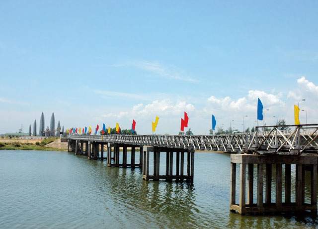
Photo of Hien Luong Bridge – Ben Hai River (collectibles).
Hien Luong – Ben Hai banks are the names associated with the historical complexes surrounding the banks of the Ben Hai river and Hien Luong bridge – historical witnesses before the “Split country” scene, before the persistent resistance war. The whole nation of Vietnam during the anti-American resistance war in 1954.
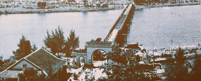
Hien Luong Bridge – Ben Hai River in the past (Photo: Collectibles).
The reason this place was chosen by the US as a place to divide our country is to create internal conflicts to facilitate the rule (Like the scene of separating South Korea and North Korea but so far has not been able to “go to the same house”. ”) Is due to the special location of the two banks here on the Vietnamese strip. This historical cluster is located on the 17th parallel from the West to the East on the map of Vietnam and is also located at the intersection of National Highway 1A and the Ben Hai River , the southern bank of Xuan Hoa village, Trung Hai commune. , Do Linh district, on the north bank of Hien Luong village, Vinh Thanh commune, Vinh Linh district invisible “split” the country.
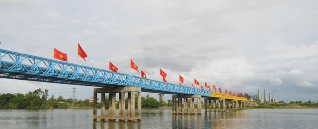
Photo of Hien Luong Bridge – Ben Hai River is divided by color (collect).
In July 1954 (one of the most memorable historical events during the nation’s long struggle to save the nation), after the resistance war against France came to victory, France and Vietnam Nam signed the Geneve Agreement, restoring peace in Vietnam on the basis of respect for the sovereignty of all three countries.
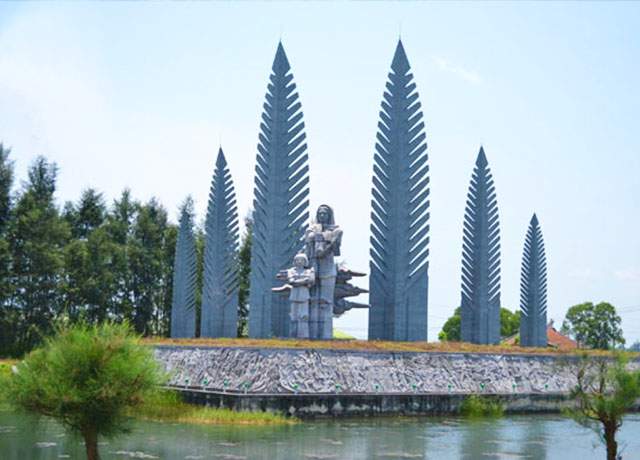
Photos of the Monument of Unified Aspiration collected.
Hien Luong Bridge , the Ben Hai river has buckled to suffer so much pain and loss during 20 years in the war against America, enduringly waiting for the independence and great victory of the spring of 1975. our country officially reconnects the Hien Luong – Ben Hai banks.
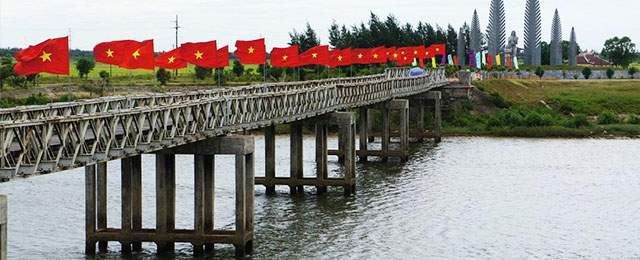
Photo of Hien Luong Bridge – Ben Hai River collected.
In 2003, our country restored the system of historical relics, creating favorable conditions for tourists to visit and remember the once-dramatic tragic past of the nation “drooping mud – getting up – bright ”.
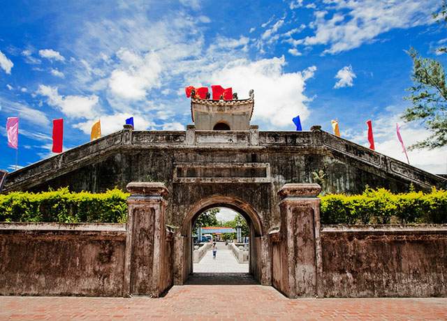
Photo collected by Quang Tri Citadel.
More than half a decade has passed, the “fire land” of the past has changed flesh. The land of smoke and smoke of the past year has given way to vast fields of rice, pepper, and green rubber forests. Along the banks of the Ben Hai River are now rich shrimp farming areas that have contributed significantly to poverty reduction here.
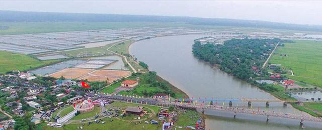
Photo of Hien Luong Bridge Relics – Ben Thuy River collected.
