
© 2023 Created by vietnampeace.com
Lam Dong is a province located in the South Central Highlands on the Lam Vien – Di Linh plateau, which is the highest land in the Central Highlands. It covers an area of 10,400 km2 and has a population of over 85,000 people. The province has many ethnic groups, such as Kinh, Co Ho, Ma, Lat, Chu Ru, and more. Its major cities and towns include Da Lat City, Bao Loc, Lac Duong, Don Duong, Duc Trong, Lam Ha, Bao Lam, Di Linh, Da Huoai, Da Teh, and Cat Tien.
Seventy percent of Lam Dong is a mountainous forest. It borders Dak Lak to the North, Khanh Hoa, Ninh Thuan, Binh Thuan to the Southeast, and Binh Phuoc and Dong Nai to the West.
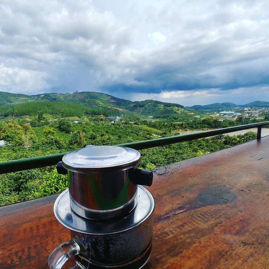
With elevations from 900 to 1500m, these highland flows have created many exciting waterfalls, such as Cam Ly, Prenn, Pongour, Gougah, Datanla, and Dambri … Lam Dong is famous for its many lakes. Poetic beauty like Xuan Huong Lake, Than Tho, Tuyen Lam, Da Nhim …
With a rich source of red basalt soil, fertile alluvium in riverside fields, and vast meadows with a climate suitable for domestic animals, especially industrial crops such as tea, coffee, and mulberry … raising high-yield dairy cows, creating favorable conditions for Lam Dong to develop the food processing industry.
Lam Dong’s forest capital is a vast, broadleaf, pure coniferous bamboo forest. Especially, Lam Dong also has the primary forest of Cat Tien. Due to the suitable climate and soil, Lam Dong, especially Da Lat, Lac Duong, and Di Linh … is the country’s most significant convergence of pine forests. Thong Lam Dong supplies the whole country with wood, paper, and coke products.
Lam Dong has Dalat City with many unique landscapes, where there are many famous landscapes and relics, and year-round cool fresh air. Dalat is the most important tourist region in our country.
Dalat tourism is vibrant. In addition to sightseeing, Dalat is also a resort for mountaineering tourism … climatologists call Dalat “the city of spring” because of its moderate temperature. The highest average day is not more than 240C, and the lowest average daily temperature is not below 140C. The average annual rainfall is 1,755mm. The rainy season is from April to November, and the dry season is from December to March. In general, all seasons in Da Lat are sunny.
Lam Dong, in general, and Dalat, in particular, are tourist paradises of our country, beautiful places with cool climates, lands full of flowers, and elegant and straightforward people.
SCENIC of Da Lat city
Located at an altitude of 1,450m, it is a famous resort in Vietnam. The hottest summers here are at a maximum of 19C. It can be said that Dalat has no summer. The year-round climate has an endless spring.
Dalat was formed in 1893 when Dr. A. Yersin, French-Swiss of origin in the Langbiang Plateau expedition, discovered Dalat. He found the climate here very reasonable.
Idea and propose to build Dalat into a resort. Since then, Da Lat City has gradually formed. Dalat’s two words have many explanations, but perhaps the most grounded is derived from an ethnographic name. Around the area of Hồ Xuân Hương valley, there was once a Lach tribe living. The first time the French contacted residents here, they heard the words Da Lach (Da is water, Lach, and Lach), which meant that this was a river and stream area of the Lach people. The French used these two words to name this area and gradually read it, deviating to Da Lat.
In addition to the very familiar name, this city has many other very sexy names, derived from the natural scenery to ecstatic people. Someone called Dalat the “city on the plateau,” in the mood of lightheadedness, refreshing, sniffing the fresh, fantastic atmosphere at an altitude of 1500m. Some people call Da Lat “the city of pine forest” because they consider the pine forest as the country’s high identity, considering the sound of pine trees to be the endless song of the country. Someone called Dalat the “city of spring.” Dalat also has another name comparable to a magnificent European famous city: “Little Paris.” Dalat also carries many other words named after the inspiration of visitors. All in all, those names came from considering Dalat to be a paradise city of tourism.
Dalat attracts tourists because of the immense pine forests, majestic, majestic waterfalls like Cam Ly, Prenn, Datanla … poetic lakes created naturally like Xuan Huong Lake, Than Breathing, Da Thien, Suoi Vang, Tuyen Lam … and gardens of thousands of purple roses. Dalat has forests and gardens in the streets … the roads wind along the mountains and rivers like cuddling and protecting beautiful villas in this painted city.
Dalat is also a land rich in cultural traditions with the Ma, Co Ho, and Chu Ru ethnic groups characteristics. Associated with the gong dance, dances by the night campfire, and jars of canned wine. ..
Da Lat is a youthful city, a place of residence for many population groups, a countryside, and also a meeting place of many different cultures, so the number of temples and churches is quite large, typical as temples Linh Son, Linh Phong, Linh Phuoc … Domain churches, Con Ga Church, palaces and hundreds of villas, architectural and cultural works, many historical and revolutionary relics.
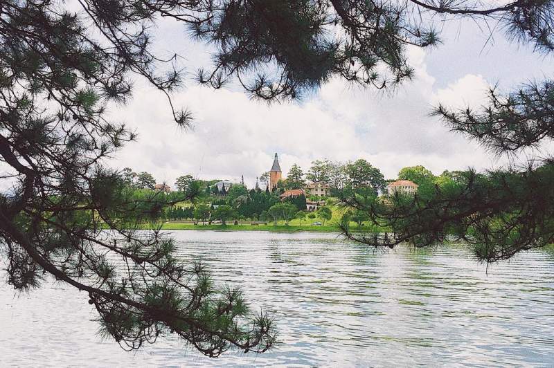
Xuan Huong lake
When Dr. A. Yersin set foot on this plateau, there was no Xuan Huong Lake today but a valley with a stream flowing through it. Due to the city’s construction planning, this valley gradually turned into a lake called Xuan Huong-Ho Xuan Huong, the most beautiful lake in the city center, the first scenic spot of Lam Dong to be recognized as a national scenic spot in 1988. The lake is about 5km2 wide. The lake is shaped like a crescent moon, attracting visitors and a dating place for couples.
The lake’s surface was as calm as crystal glass, reflecting the pine trees. The road around the lake and colorful flower gardens, full of pine trees, every spring when cherry blossoms bloom, glow a soft pink around the lake.
In their free time, visitors can sit under the old pine trees, let go, cruise on the lake, or stop at the barbell to enjoy freshwater with the flavor of Da Lat, the mountain town.
Prenn Waterfall
It is located at the foot of Prenn Pass, next to Road 20 from Ho Chi Minh City to Dalat, and 12km from Dalat Center through Prenn Pass. According to the Cham language, Prenn is the boundary. Formerly, many centuries ago, the Cham people always had skirmishes with small tribes in Lam Dong. Prenn is the boundary line and also the place to restrict. From Prenn down to Don Duong, Phan Rang belongs to the Cham people, and from Prenn and up, it belongs to the Co Ho and Ma people.
Prenn Waterfall is about 6m high. Water fell from the rocks and looked like it had dropped from the sky. So Saigon people have called this waterfall Thien Sa.
Since 1998, with the upgrade of tourism services here, Prenn Waterfall has become a popular tourist destination.
Prenn has a special dish that cannot fail to be mentioned. It is the snakehead fish porridge in the best type of Dalat.
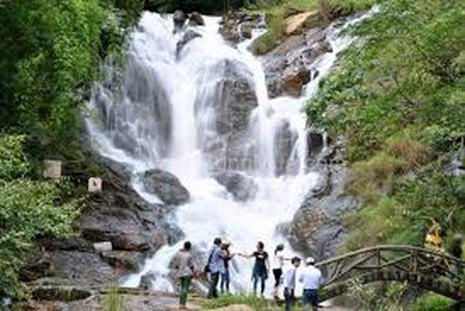
Datanla Waterfall
5km from Dalat center, next to Prenn, pass to the city. The waterfall is quite deep, nestled in a mountainous area. This used to be the refuge of an army of indigenous people in the fight with the Cham hundreds of years ago. Thanks to this waterfall, an army has stayed and preserved forces. According to the ethnic language, the Datanla waterfall’s name is water under rocks and leaves.
According to legend, Datanla was where the brave K’lang and the H’biang met. Here, the K’lang fought with fierce beasts of two chimpanzees, seven wolves, and two foxes. The fighting was fierce. Taking advantage of the two snakes sticking out their tongues, K’lang pulled out the knives to cut off the snake’s two blades, then shot nine arrows at the wolves and foxes to make them flee. Falling trees create deep pits; one is the Grim Reaper at the foot of the falls. From there, Datanla became the dating place for K’lang and H’biang.
At the head of the waterfall is an immense pine forest, hundreds of years old, with pine trees that one can not hug.
Ho Than Tho
Far from the city center, about 5.5 km to the North, along Quang Trung – Ho Xuan Huong Street. For a long time, Than Tho Lake has been famous for its verse:
And so far, the Thao-Tam story is still closely linked to the legend of the “Two-grave Pine Hill.” There are still tombs of the unfortunate girl named Thao lying coldly on “Two-grave Pine Hill.”
In the eighteenth century, the ancient legend also said that when the hero of Hue Hue clothed his army to drive away from the invaders of the Qing Dynasty, boys everywhere responded to enlist soldiers, including Hoang Tung. Before enlisting in the military, Hoang Tung and Mai Nuong invited each other to the shore of Than Tho Lake to swear an oath. He promised that in spring, when the apricot blossoms, the cherry blossoms will bring news of the victory. At Mai Nuong’s home, Hoang Tung died in battle, so she decided to immerse herself in the lake. Ironically, until the spring of the victory, Hoang Tung returned, he suffered when he learned that his lover had committed suicide.
A few years later, when the Tay Son Dynasty collapsed, Gia Long took revenge on the people who had contributed to the Tay Son Dynasty, so Hoang Tung jumped into the lake to commit suicide to be happy with his lover in nine streams. Since then, the lake has been called Than Tho so far.
Since 1997, Than Tho Lake has been assigned to Thuy Duong Co., Ltd. for effective management, investment, and exploitation. Beautiful lake park day by day.
Valley of Love – Ho Da Thien
About 5.5km from Dalat to the North. Formerly, it was a large valley named the Valley of Love. The scenery is stunning. During the French colonial period, this valley was known as Valle D’Amour. In 1953, following the policy of the Da Lat Town Council, it was Vietnamized into the name of Love Valley. In 1972, the Da Lat government built a dam to prevent water, creating a large reservoir and supplying water for agricultural production in the Da Thien area (now ward 8 of Da Lat), so the lake was named Lake Da Thien.
There is also a theory that this valley is near the University Institute (now Dalat University), where students often date at the end.
Week to confess love, so students called it the Valley of Love. There is also the idea that the name of Love Valley comes from the name of the novel “Valley of Love,” published in the early 1970s by a female writer.
Love Valley of Ho Chi Minh Valley, with many beautiful and gentle pine hills, is suitable for picnics on holidays and holidays with over 242ha. The lake area is 13ha. In the message range is a hill called “Vong Canh,” a house for guests to rest and admire. You can see the legendary Langbiang mountain and the whole lake from here.
Golf course – Cu Hill
Dalat has three adjacent Cu hills, formerly built by the French into a 9-hole golf course. As a king, mainly in charge of the Reigning Government, Bao Dai often played golf here with French officials.
In the early 1990s, the golf course was built into a joint venture between Lam Dong Tourism Company and DANAO Company (Hong Kong), and an 18-hole international golf course was built.
Doi Cu golf course, Da Lat, is one of the most beautiful golf courses in the world.

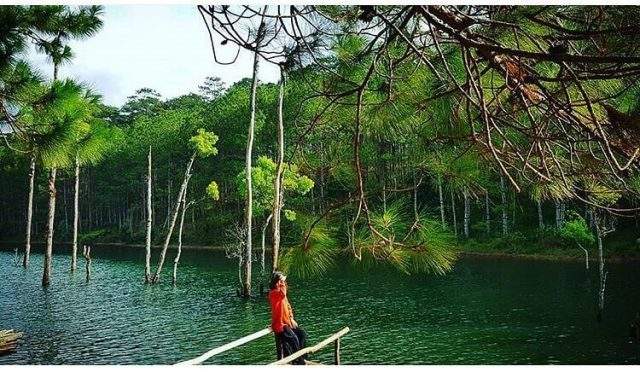
Dankia-Suoi Vang Lake
12km from Dalat city to the North, Dankia-Suoi Vang Lake looks like a young girl who has just entered adolescence, lying on the green pine hills. 1893 Dr. Yersin was ecstatic at the majestic mountains’ fairy beauty on the Langbiang plateau. From here, I came up with the idea of setting up a resort on this plateau – Dalat City.
Suoi Vang Lake consists of two lakes, Dankia and Ankorét, with a capacity of about 21 million km3 of water, providing water for two power plants.
And it was running water for people in Da Lat. Right below, Dankia Lake is a beautiful Bay floor waterfall. The name Golden Stream does not know who to give; is it because there is a lot of placer gold here?
The Ankorét hydropower plant was the first hydroelectric plant in Vietnam in 1943. 2000, the Dankia – Suoi Vang Lake area inaugurated the water plant’s renovation and improvement. According to the Government’s plan, this place will form a second Dalat, with high-class resorts, villas, entertainment areas, and a high-class road from the airport. Cam Ly to Dankia – Suoi Vang.
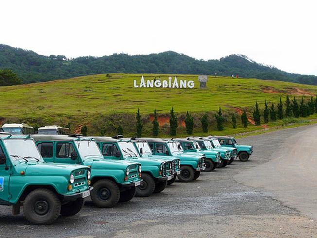
Mountain Langbiang
It is located in Lat commune, Lac Duong district, about 10km north of Dalat city. Langbiang mountain range consists of three central mountains: Giant Mountain K’yut, Ong Lam Vien Mountain, and Ba Mountain (Bi Dup).
In the middle of the mountain was a large valley, where it succeeded in celebrating the 100th anniversary of Da Lat city’s founding, so it is now named Hundred Years Valley, which can meet the needs of camping and night campfire activities for thousands of visitors. Here, visitors can spend the night in a tent, watching the gong festival of the Co Ho people living at the foot of the mountain.
From the valley, there is a car to transport visitors to the top of Mount Rada to enjoy the beautiful moments of harmony of heaven and earth. The clouds floating overhead were almost blue. West of Suoi Vang, streams flowed, crossing like pure silk strips. On clear days, from here, visitors can zoom their eyes down to Phan Rang, Nha Trang, and the white sandy lobular domain.
Coming to Langbiang, you will be given the name of Langbiang Mountain through the “natural love story” between a K’lang boy and an H’biang girl, people of two different tribes. They fall in love with each other passionately, swearing young, dating by the sea. Unfortunately, the two tribes had a feud, and the curse was not married. But the couple were determined to overcome the curse. They decided to go to the top of the highest mountain to live and settle. Sometime later, unfortunately, H’biang fell ill. K’lang tried to cure everyone but ran away and went to the village to ask for help. Believing, a group of people came. When the boys and girls were near, one of them pulled an arrow soaked in poison. H’biang could see and quickly tried to shield his weak strength with K ‘lang, and the dead poison hit her. K’lang grieved and cried H’biang for three nights and three days. His tears flowed into lakes and significant streams to make Da Nhim hydroelectricity today (Da Nhim or Da Nhim in ethnic languages are tears ). The love of the two villagers admired them, so they took their names and gave the highest peak of Langbiang. The mountain has two peaks named Mount Ong and Ba Mountain (collectively called Ba Mountain because of matriarchy).
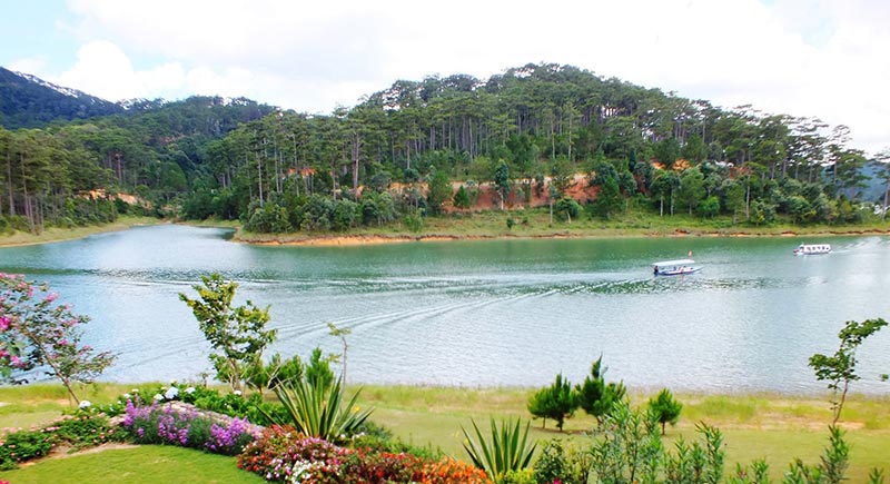
Tuyen Lam Lake
7km South of Dalat center and 2km from Datanla waterfall. From Road 20 (Ho Chi Minh City to Da Lat), turn down a slope of about 2km to Tuyen Lam Lake, a 350-ha lake. Sailing on the lake, visitors feel refreshed with immense blue water stretching to the horizon. Close to the lake is a high mountain, Truc Lam Zen Monastery is located on it. Visitors to Tuyen Lam, besides yachts, can ride elephants around the lake.
Dambri Waterfall
Far from Bao Loc town, 18km away, the waterfall is 57m high. In 1999, Dambri Tourism Company invested VND 1.5 billion to lift an elevator into a waterfall and build a 5 ha forest to support 500 monkeys, deer, bears, panthers, crocodiles, and a bird collection.
Dambri waterfall in the Vietnamese language means waiting for the waterfall. The story goes that once upon a time, a couple was in love. His name is Dam, and the girl’s name is H’bi. H’bi was the daughter of a wealthy, powerful, cruel chief who did not want her daughter to marry the poor Dam, so she tried to banish Dam to a remote and faraway place. Because I miss my love so much, H’bi came here crying and waiting for my lover daily. But wait forever; I have passed several fields but still do not see Dam. One day, the village heard a scream. When the whole town ran out, H’bi transformed into a waterfall. Since then, the villagers have named the waterfall Dambri.

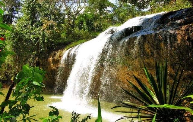
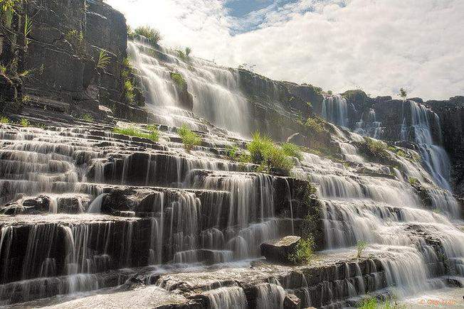
Pongour Waterfall
It is located in Tan Hoi commune, Duc Trong district, 54 km from Da Lat, about 20 km from Road 20. Pongour Waterfall is the most beautiful and majestic waterfall in the Central Highlands, with a height of 20m, a surface hundreds of meters long, and a width of tens of hectares. In the dry season, not much water can be organized for thousands of people to play here simultaneously. The discerning traveler did not hesitate to call Pongour Waterfall the “Southern Southern First Waterfall.”
Pongour Waterfall is associated with the story of Ka Nai, a beautiful chieftain who has contributed to building a prosperous life for the Co Ho people. It is said that Ka Nai has four rhinos, and Pongour is a trace of rhino horn in the ground.
On the full moon of the first lunar month, it hosts a waterfall festival with thousands of participants, mostly young men and women.
Tiger Cave Waterfall
Da Lat has long been renowned for the breathtaking beauty of its majestic waterfalls, such as Cam Ly Waterfall, Prenn Waterfall, and Voi Waterfall. Tiger Cave Waterfall in the White Valley is a captivating destination, drawing many visitors with its pristine and untouched charm.
Situated approximately 2.7 km East of National Highway 20 (QL20) within a 308-hectare pine forest, Tiger Cave Waterfall is a natural wonder with a height of about 50 meters and a length of 500 meters. Besides its familiar name, Tiger Cave, the waterfall is also known by various other names like Đạ Sar Waterfall, Long Nhân Waterfall, Ông Thuận Waterfall, or Thiên Thai Waterfall.
Approaching the waterfall, the echoing rush of water and the melodious singing of forest birds create a tranquil atmosphere. It feels as though the surroundings are detached from the hustle and bustle of urban life, leaving only ourselves immersed in the symphony of nature, a genuinely refreshing sensation. Everything around seems to wash away the weariness of the journey. To reach the head of the waterfall, you’ll have to wade through a small stream, still preserved in its pristine state.

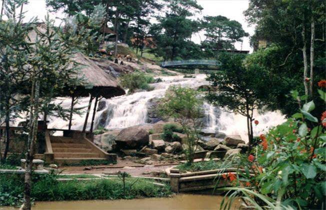
Cam ly waterfall
It’s not very tall but amicable and in the city’s heart. Cam Ly Waterfall consists of the Cam Ly stream flowing from above through Xuan Huong Lake, weaving through residential streets, facing the West, and pouring water into the falls. Beautiful Cam Ly waterfall went into people’s hearts through poetry and music:
Lien Khuong Waterfall
It is located near Highway 20, Duc Trong district, 27km from Da Lat. The waterfall is 50m high, has a pretty long surface of about 200m, and is also one of the majestic waterfalls of Lam Dong. But in the dry season, Lien Khuong waterfall has very little water.
Gogah Waterfall
They are also known as Lo Ga waterfall, 38km from Da Lat and about 300m from Highway 20. From Da Lat to Ho Chi Minh City, passing Lien Nghia town about 8km, meet the left-hand fork.
According to legend, Gogah was a bottomless abyss, the treasure of Queen Naf Biut (wife of King Champa). Naf Biut was originally Vietnamese, married to the Champa king, and favored by the king. To cure the queen, the courtiers said that it was necessary to build a palace outside the Champa Kingdom for the queen to recover. Later, the queen died; the king buried the queen in this wilderness and buried it with pearls and jewels for the queen to use. According to the Cham people, that queen was Huyen Tran, princess and daughter of King Tran. (According to history, it is not valid.)
Ivory Elephant Falls (Po Pla) is Located in Lien Dam commune, Di Linh district, more than 80km from Da Lat and 25km from Bao Loc town. The waterfall is about 300m from Highway 20; the ethnic people call this waterfall Po Pla or Ivory Elephant, and the Vietnamese call it Bobla or Lien Dam waterfall.
The waterfall is nestled between two hills shaped like an elephant. Under the waterfall is a small lake due to the water pouring down, creating a long time. Next to the lake are large rocks like the stone tables of heaven, with tall old trees covering a whole sky.
Ivory Elephant Falls has a narrow face, about 20m high. It is said that when the Cham ruled the Di Linh country, they forced the indigenous people to pay taxes on forest products such as fur, rhino horn, and ivory. Tusks must choose the big—the head of the tribal tribes where the waterfall had found a pair of tusks above his head. Cham king liked it, so he named it Po Pla and the waterfall from there was also named Po Pla. Lien Dam’s name is due to reading the camp from the words Liang Dam, a talented boy who saved the villagers of Liang Trakk Mur from enemy looting. At one time, the enemy attacked the village, and the whole town was afraid to flee; only Liang Dam did not run. He broke a branch of the brooch on the waterfall bank and pointed to the enemy. Strangely, when the branch was broken, the enemy broke and killed himself. After the enemy was defeated, Liang Dam quietly walked towards the waterfall and disappeared; the villagers could not give thanks. To remember the merits of Liang Dam, the villagers named the village Liang Dam, and the waterfall also bears this name, but because the Vietnamese people read the camp, they go to Lien Dam.
RELICS
Linh Son Pagoda
Located on a hill on Nguyen Van Troi Street, Da Lat City was built in 1936 and completed in 1940. The pagoda’s architecture follows the East Asian style. Four large pillars are in front, under the roof border decorated with a stylized “thousand” (^) pattern. The main temple is a bronze Buddha statue, cast in 1952, 1.72m high, weighing 1,250kg, sitting on a lotus seat. On the right of the inner Palace is a giant rosary weighing 450kg hanging on a wooden shelf. Behind is the sugar hall, the place of worship where Dat Ma and the monks passed away. Linh Son Pagoda has a large lecture hall built in 1972, now the Lam Dong Buddhist School.

Linh Phong Pagoda (Temple of Female Women)
Located on the highest hill of Hoang Hoa Tham Street, Da Lat City built in 1944, the Buddhist Recitation Hall of Venerable Thich Bich Nguyen. From 1948 to 1962, the monk Thich Nu Tu Huong was restored to the current Linh Phong nun. The temple has a communal-style architecture, a two-story Tam Quan gate roofed with tiles, three arched arches on the bottom, a rectangular corner door, and the “Linh Phong tu” sign. In the middle of the main hall’s front yard is a Buddha Guan Yin statue with white plaster on the lotus.
The main temple is dedicated to the Amitabha Buddha statue, painted with gold-plated lipstick, 1.8m high, carved in 1949. The two sides worship Quan Am and Dai The Chi. Behind is to worship To Dat Ma and Venerable Thich Quang Duc. Next is the rear house, the nun’s residence, and the Spirit’s temple.
Linh Phuoc Pagoda
Located in Trai Mat, 8km from Da Lat, near the old Highway 27 (Phan Rang – Da Lat), inward 11, Da Lat City, was built in 1949, completed in 1952, and restored by Great Venerable Thich Tam Vi in 1990.
The pagoda architecture is in Asian style. Gate three observes the National Highway 27. In front of the yard is the Buddha Ba Quan Am temple. The main temple, which is 4.9 meters high (including the lotus seat), is to worship Thich Ca Buddha. On both sides of the inner Palace are two rows of dragon-shaped mosaic columns, on which are porcelain mosaic reliefs, telling the history of Buddha. Before the picture of the Nine Long Buddha bending his body to worship Buddha. The front of the pagoda is a 27m high stupa. The road to the right of the main hall. Next to it is the flower garden and the Venerable Stupa. On the left of the main hall is Long Hoa Park, with a statue of Bodhisattva Maitreya situated on an imitation stone mountain.
Truc Lam Zen Monastery
The monastery is on the Elephant Mountain, overlooking Tuyen Lam Lake, in Ward 3, Dalat City. The Zen Monastery started construction on May 28, 1993, on a 25-ha site, of which 2 ha built the monastery and the surrounding 23-ha garden. The monastery was inaugurated on March 19, 1994. The Truc Lam Zen Monastery abbot is the Venerable Thich Thanh Tu, the abbot of Thuong Chieu Monastery in Dong Nai.
Thien Vuong Co Sat Pagoda
It is also called Tau Pagoda or Buddha Tram Temple. The pagoda was built in 1953 by Venerable Tho Da, a Chinese man, on a green pine hill at 385 Khe Sanh Street, Da Lat City. In 1989, Mr. Le Van Canh organized the restoration.
Thien Vuong Pagoda follows the Hoa Nghiem sect of Chinese Buddhism. The temple consists of three yellow buildings. In Minh Quang, he told the temple to worship Western Tam Thanh, Amitabha Buddha, Bodhisattva Guan Yin, and Dai The Bodhisattva. Each 4m high, weighs 1.5 tons, was brought from Hong Kong Buddhist monk Tho Da in 1958.
There is also a 2.6m high Tu Thien Vuong statue in cement.
Linh Quang Pagoda
The pagoda was founded by Thich Nhan Thu in 1931, and it is located at 133 Hai Ba Trung Street, Da Lat City. Afterward, it was restored by the following monks to restore the temple. Especially in 1958 and 1972, under the monk Thich Minh Canh’s abbot, the pagoda was overhauled. In the corners of the temple, the roof is covered with a sophisticated and sophisticated phoenix. There is a tomb area within the pagoda.
Chicken Church, Cathedral Cathedral
Local people called the Chicken Church because the roof of the bell tower has a chicken model. The church was built in 1931, with a 47m high bell tower. The church is located on a vast campus in the city’s center.
Domain church
Diem, this Palace was reserved for the family of adviser Ngo Dinh Nhu.
Besides the Palace, the French
The name is Mai Anh church because, in the past, there were many apricot flowers and cherry blossoms. From 1940 to 1943, this was the chapel of the Charity nun. In 1943, the church was rebuilt in a strange architectural style, unlike any other.
Although the church does not have a bell tower on the top, the top is an isosceles triangle; the front is decorated with small arches. Walls of stone split to the window sill in the style of Normandie architecture (France)—stained glass frames illuminate interior space. The church has a 3m high statue of Our Lady of Grace weighing 1 ton as a gift from the Governor-General of France Decoux.
Domain Church only uses pink lime to sweep the walls. This is the resting place of Lady Decoux, buried in the back corridor of the church. She is the church’s patron, and her wish is that after her death, she will be buried in this church.
Dalat Railway Station
It is located to the East, 500m from Xuan Huong Lake. This is a train station for the railway section from Dalat to Phan Rang-Thap Cham. This railway section started construction in 1915, is 84 km long, and was put into use from 1928 until 1964. It stopped operating because of the war. Today, Da Lat railway station only serves passengers traveling on the 8km road from Dalat station to Trai Mat.
Station architecture is modern, combined with the Central Highlands’ unique type of communal house.
Dalat University
It was located on a green hill at the end of Cu Hill, north of Xuan Huong Lake, on Phu Dong Thien Vuong Street, on a 40ha campus. The school was founded in the 1950s as a Private University Institute under the Catholic Bishops Conference of South Vietnam. Formerly, it was the Europe – Asia Mixed Military Students school.
Before 1975, this university had political and business faculties, which gathered many students to come here to study, with the number of students up to 1,000. On the buildings or lecture halls of the Institute, you are entitled to take names from Trung Dung books and scriptures such as Nang Tinh, Dat Nhan, Tri Nhat, Minh Thanh …
After Liberation Day, the university was quickly restored to a general and multi-disciplinary university, meeting the demand for knowledge training for the South Central and Central Highlands. Students study in all regions of the country—the number of students attending school increases yearly. The university enrolls about 10,000 to 13,000 students in 22 majors in 10 faculties each year.
Palace 1 (Electric Palace 1)
Follow Tran Hung Dao – Hung Vuong Street to the Trai Ham junction, turn left about 400 meters, and you will arrive at Palace 1. Nguyen is the property of a Frenchman, Bao Dai, who bought and built the headquarters of the Government of the Imperial Court of China. During the reign of Ngo Dinh Diem, it was fortified into a magnificent and solid castle. There is an emergency tunnel under the main building; the main entrance to the tunnel is right next to Ngo Dinh Diem’s bedroom (located halfway up the stairs upstairs, looking like a standard room, so hard to detect)—the exit tunnel behind the Palace to the place where the helipad is about 100m long. The Palace is on a large campus with many ancient pines and flower gardens.
Governor General’s Palace (Palace No. 2, Palace 2)
The Governor General’s Palace is located next to Tran Hung Dao Street, on a high hill of 1,533m. It is in quite an excellent position, one side overlooking the Xuan Huong Lake, the other overlooking the pine forest. When he was still in office, Governor-General Decoux built this mansion as a summer resort. To avoid danger, this Governor-General has built a secret tunnel so that he can escape if there’s an incident. For many years without maintenance, the tunnel was extensively damaged.
During the reign of Ngo Dinh, a superficial office was also built. In the Palace are some precious artifacts such as mother-of-pearl mosaic pictures, engraved poems of King Tu Duc, and Lady piano of Lady Decoux.
Palace 3
Located on Trieu Viet Vuong Street, about 2.5 km South of Dalat City Center, it was built in 1933. In 1937, when it was inaugurated, former Emperor Bao Dai used this place as a summer resort. When the French returned to Vietnam, bringing Bao Dai as the puppet chief in 1950, he used it to live and work.
The Palace has two floors; the ground floor serves as a venue for meetings, banquets, and receptions for foreign guests and officials of the Imperial Territory government, including rooms: work, reception, party, private secret room, and playroom of the princess and the prince. In the communal room, a painting of the Angkor Vat temple was presented by Prince Sihanúc (Cambodia) to Bao Dai.
Above the room is the room of Bo Dai, Hoang Nam Phuong, Prince Bao Long, Princess Phuong Mai, Phuong Lien, Phuong Dung, and Prince Bao Thang. Outside the restroom of Bao Dai is the moon’s floor, used as a place to watch the moon.
Under Ngo Dinh Diem’s reign and later Nguyen Van Thieu’s, this Palace was a high-class resort of the Saigon government.
After the South was utterly liberated, this Palace belonged to the Financial Committee of Lam Dong Provincial Party Committee, which has now been handed over to Lam Dong Tourism Company for management.
Cat Tien relics population
It is located in Quang Ngai commune, Cat Tien district, about 35km from Highway 20. From Ho Chi Minh City to Maadagui junction, turn left along provincial road 721 and go about 35km to the monument.
The relics were discovered in 1985, and there have been three archaeological excavations. The ruins include temples and tombs of the Funan Kingdom, which were destroyed 13 14 centuries ago.
The monument’s most significant scale is Doc Monkey Temple (Mound 1A), located on the highest hill, facing east. They found a vast Linga-Joni (the Brahmin religion) at this temple tower. According to beliefs, the Brahma people always pour water on the statues when going to the temple. If you want to give birth to a daughter, then touch Joni. If you’re going to give birth to a son, touch Linga and collect water from the Joni statue slot to flow to drink.
Near 1A temple, there are also small temples, including one close to the Dong Nai river banks with beautiful walls.
FESTIVALS
Lam Dong has a legendary Tay Nguyen cultural identity, a region with many ethnic groups still retaining traditional festivals and customs:
Buffalo eating festival
Of the Co Ho ethnic group, it is often celebrated after the affair
Harvest prepare for new crop season. During these holidays,
Co Ho people play many traditional ethnic instruments.
Next to the fire and the jars of canned wine, the elder told his children and grandchildren many tales and legends, explaining poems and folk songs about their race and homeland.
Spirit worshiping ceremony
Of the Ma people. The Ma people believe in the gods: God is the supreme God, the God of the River, the God of the Mountain, the Fire God … in which the Ma Suoi worshiping ceremony of the Ma people carries many folk beliefs.
Ceremony to worship Bo Bo Mung
This is the worshiping ceremony for the Ru Ru people’s God, the most significant ceremony of the year for the Chu Ru and Lam Dong ethnic groups. The ceremony is usually held in the second lunar month every year. This ritual is asso